Messing with Texas
If you are like me, part of the difficulty of researching and then writing about something is that you end up discovering all sorts of other interesting stories in the process that want to pull you away from what you are supposed to be focusing on. Very quickly these become their own piles of scribbled notes and bookmarked browser tabs and staying up too late “to look up one more thing…” side projects, with the end result that you never end up finishing any of it.
My recent deep dive into all things Pinckney/Pinkney Street has left me with dozens of these stories, some little, and many not so little that I am going to try and finally clear off my desk. This first one is most closely related to the Pinkney street naming saga: the reason behind the ”missing” state street names from the core of Lawrence (Georgia, South Carolina, North Carolina, Virginia, Maryland and Texas).
The answer turns out to revolve around a treaty that the US government signed with the Wyandot Native American tribe when they lived in northern Ohio in 1842. And maybe a hill. Buckle up folks, ‘cause it’s gonna get convoluted!

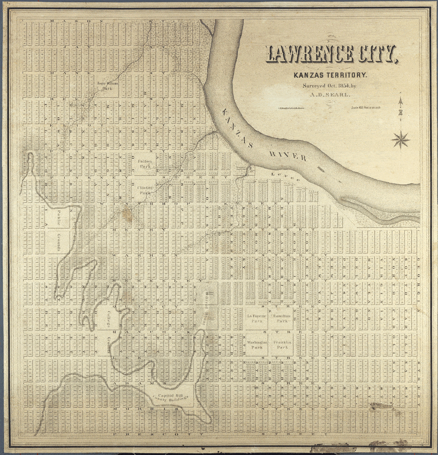
AD Searl’s 1854 map of Lawrence. Click for embiggened version here.
To recap, all six of those missing state streets are shown on the original ‘map’ of Lawrence, as surveyed and plotted by A D Searl in the autumn of 1854 and labeled by Dr. Thomas Webb, secretary of the Massachusetts (later New England) Emigrant Aid Company that same fall. That map, however, was nothing more than wishful thinking, a city of three square miles when the law only allowed them to claim one sixth that amount for a settlement, and plotted out on land they might not even have a right to settle on in the first place.
Get your float on!
This is where the 1842 treaty comes in. When the federal government negotiated to move the Wyandot tribe from their ancestral lands in northern Ohio to northeastern Kansas, one component, Article 14, created special land grants for 35 named members of the tribe. Each one of those people were reserved the right to select a single section of land (or 640 acres, or a square mile) anywhere west of the Missouri river. Because these reservations were not tied to a specific piece of land, they were considered “floating reserves” or “Wyandot floats”.
For a variety of reasons, including the indifference of the federal bureaucracy overseeing Native American affairs at the time, almost none of these Wyandot floats had been patented at the time the Kansas Territory was opened to white settlement in 1854. Soon after, the Wyadot tribe revised their 1842 treaty, formalizing their ownership of land near the confluence of the Kansas and Missouri rivers, selling off other land, and updating the nature of the floats, making them now eligible to be placed on any federal land west of the states of Iowa and Missouri, and allowing the floats to be assigned or sold.
White settlers, land speculators and town agents alike quickly saw the value the “floats” could have to add legal heft to the status of their otherwise uncertain claims. And Lawrence very much had uncertain claims. For the first winter and spring of its existence, sparring groups of townspeople (who had formally organized themselves as the Lawrence Association), squatters and speculators fought over who had the right to be there, sometimes in lawsuits and claims at far off courthouses and land offices, sometimes by physically removing camps and structures. In the end, the Lawrence Association negotiated a deal with a group of squatters, led by William Lykins, who held claims on much of central Lawrence. In an effort to protect the deal and the nascent town of Lawrence from further claims, the combined group acquired the Wyandot reserve # 12 from Robert Roubatille and placed it over the heart of the Lawrence townsite in the spring of 1855.
Around that same time, a separate group of early NEEAC settlers and out-of-territory investors obtained another Wyandot float, the Joel Walker float (Wyandot reserve #5), and located it just to the west of central Lawrence, calling it West Lawrence.
Searl would re-survey and replat the town to the new boundaries created by dropping these two, roughly square cookie cutters on the old map, to create the first true map of Lawrence in 1857. (Although this map is undated, there is very strong evidence to place its production in 1857, which is detailed at the end of the article)

AD Searl’s 1857 map of Lawrence. Click for embiggened version here.

The entire area of the city west of Alabama and south of Warren is now gone. A formal boundary was set at Maryland street to the east. Halfway between Adams (now 14th) and Morris (now 15th) Street was now the southern boundary. And so Lawrence lost Georgia, South Carolina, North Carolina, and Virginia streets in the east and the distance between the current 14th and 15th streets is half that of any of the blocks north of 14th.

Details from the southeastern portion of the 1857 map of Lawrence - several state streets lost and the distance from 14th to 15th streets (at the bottom) halved.

Detail from the northwestern portion of the 1857 Lawrence map. Jay Street is now the northern border and Iowa has leapfrogged California
In West Lawrence, Mason (what would have been “Zero” Street had the grid never changed) was lost, leaving Jay (what would have been 1st Street) as the northern boundary. Additionally, the orderly city blocks filled with small residential lots envisioned in the 1854 map give way to larger and larger lots west of Michigan street, likely owing to the demands of the groups that invested in the land there. Texas Street, originally between Florida and Wisconsin, disappears from the northern portion of the map, although three blocks of it still run from Pinkney (now 6th) to Warren (now 9th) streets. The original location of Iowa Street is no longer there, but instead of shifting everything, Searl kept California in its ‘original’ location and Iowa leapfrogs it to be the westernmost street on the map of Lawrence. (If it hadn’t, the current Iowa Street might’ve ended up being called California Street)
More surveying by the state and federal government would be done in the next few years, adjusting Lawrence’s borders again as the entire region was stitched into alignment with township and county borders. And although no other maps from this era - including official plats used by the city for maintaining property locations and records - survived Quantrill’s raid in 1863, the first maps produced after showed a few more streets being squeezed out as a result of the process
Maps produced after the raid are broken up by the Wyandot float they were initially limited to. The map of central Lawrence, formally received by the city no earlier than 1866 (the first year S.S Horton became Register of Deeds) has Delaware street as the eastern edge of the city:


Detail from 1866 map of Lawrence
As for West Lawrence, the earliest post-Quantrill map is from 1868, and Jay is gone from the north, and the remainder of Texas Street was written out of Lawrence history as well. Texas’ demise appears to have been a practical, rather than cartographical, decision. Nothing to the west of Michigan Street made it south of what is now 6th Street as drawn on Searl’s map, likely owing to the steep hill that begins to rise there.


Detail comparison of 1857 and 1868 maps of West Lawrence
And that’s how Georgia, South Carolina, North Carolina, Virginia and Maryland got squeezed out of Lawrence and Texas got erased. When I first started looking into these things, I’d thought that maybe there was something deliberate in their disappearance, as all but Maryland were part of the confederacy. But sometimes history is as much the cumulative acts of a ceaseless bureaucracy as it is the deliberate actions of determined men.
TRIVIA EXTRAS
Basic Trivia: South Park was originally a far bigger park than what we have now - it was supposed to stretch north-south from 11th St to 13th Stand east-west from Rhode Island Street to Tennessee Street. But in the deal the Lawrence Association made with the Lykins group to settle their land claims, the agreed to give members of the Lykins group so many lots in the city that there weren’t enough to satisfy the Free State settlers. So they carved more lots out of the boundaries of South Park, reducing its overall size by more than half.

Bar Trivia: Final lawsuits by people & groups claiming ownership of the land Lawrence sits upon would not be settled until 1865 when the Wyandot float for West Lawrence was officially patented.
Showing off Trivia: In 1854, some squatters attempted to bolster their claim to the land Lawrence is now on by partnering with a land agent and surveying and laying out streets of an entirely different town which they named “Excelsior”.
LFK Trivia: There was a Wyandot float that was supposed to fill in the southwest corner of Lawrence that is missing from the 1857 map, acquired by Lawrence founding father (and first governor of Kansas) Charles Robinson for that purpose. Ultimately it was used to claim land near Pike’s Peak, and holy schnikes the story of it and how the final boundaries of the other two floats that formed Lawrence got settled sounds bonkers.
From an article about the Wyandot floats:
Additional problems arose because of the arrival of James H. Lane, who bought out a claimant on the fringe of the colony. Lane, a lieutenant colonel in the Mexican War, former lieutenant governor of Indiana, and only recently a member of congress, was a hard man to have for an enemy. The land claim contest, involving Lane and Gaius Jenkins has been justifiably identified as “the most famous… which arose in Kansas,” and it had its repercussions on the use of Wyandot floats on the Lawrence townsite. Where else could one find a killer in a homicide case (Lane) gain exoneration for his crime, get elected to the United States senate shortly afterwards, and have his land claim resolved to his satisfaction? In the process two Wyandot floats had to adjust their boundaries to Lane’s demands, and a third float [Robinson’s] was relocated.
Details of the 1857 map of Lawrence
AD Searl resurveyed Lawrence at the time each of the two Wyandot floats were used to secure Lawrence’s borders. A court filing defending the townsite against other claimants noted that Searl surveyed the No. 12 Wyandot float on April 3rd, 1855:

And on the post-Quantrill’s raid map of West Lawrence (situated on the No. 5 float, Searl wrote: “I hereby certify that this is a true and correct plot of Wyandotte Reserve No. () or what is known as the Joel Walker Float. The blue line represents the boundary of the Reserve as surveyed by me June 22nd, 1855 … Soon after the original location of the Reserve, I surveyed it into Streets, Lots and Blocks as shown on this Plat.”

Two letters written to Hiram Hill, an investor in property in West Lawrence, in 1857 by his agents in the territory note a map of the area was to be soon available. H.M. Simpson wrote Hill on Jan 17, 1857:

“We Shall have maps of West Lawrence as soon as they can be lithographed”
Erastus D. Ladd’s letter to Hill on June 29, 1857 explained the unusual reason for a delay in getting the map of West Lawrence to Hill:

“Mr Searl informs me that the maps of W. Lawrence were lost in the sinking of a boat on the Missouri river. and that he has ordered more.”
Finally, Searl’s partner named on the map, Eugene Burke Whitman, would leave the territory in 1858, meaning the map couldn’t have been produced any later than this.
Important Sources
Wyandot Floats, Homer E. Socolofsky
https://www.yumpu.com/en/document/read/12355526/wyandot-floats-wyandotte-nation
Originally published in the Kansas Historical Quarterly, Autumn 1979, Volume XXXV Number 3
The Kansas Conflict, Charles Robinson
https://www.google.com/books/edition/The_Kansas_Conflict/AvZ5AAAAMAAJ?hl=en
History of the State of Kansas, volume 1, Alfred Theodore Andreas
Claim Troubles (p 314) https://babel.hathitrust.org/cgi/pt?id=umn.31951p01071158p&view=1up&seq=302
Albert Dwight Searl: A Free-State Surveyor in Bloody Kansas
https://blogs.lib.ku.edu/spencer/tag/maps/
Partisan Cartographers During the Kansas-Missouri Border War, Karen Severud Cook
tinyurl.com/mryeuvs3
Brief for Applicant in the matter of the “Wyandott Robitaille Float.”
https://territorialkansasonline.ku.edu/index.php?SCREEN=show_document&SCREEN_FROM=immigration&document_id=102592&FROM_PAGE=&topic_id=88
https://www.kansasmemory.org/item/3997
Earliest Post Quantrill’s raid maps of Lawrence
Douglas County Register of Deeds office
Create a free log in at https://landmark.douglascountyks.org/LandmarkWeb/Account/LogOn; then search by book and page. The Book Type is Plat Book. Enter Book 1, Page 1, the results “West Lawrence” and “Lawrence - original townsite” have the oldest maps